Conservation Planning
Humans are powerful agents of change. Human activity has dramatically altered landscapes and transformed our global biosphere in order to sustain our needs and desires, resulting in huge shifts in ecological processes felt around the planet. Modern land use and development patterns have led to reduced and unstable natural systems, ecological failure, lack of water, reductions in biodiversity, extinction, urban heat island effects, and global climate change.
Conservation planning is playing an ever-increasing role in mitigating land use impacts. With a forward-thinking approach, our land conservation planning services preserve biodiversity, vital resources, and places for people to enjoy and interact with nature. Conservation protects fragile environments while sustainably fueling local economies and addressing climate change. Our conservation planning services empower clients to determine conservation priorities within their scope. Our work has helped numerous agencies, organizations, developers, and land owners sustainably use their resources to simultaneously accomplish economic and ecological goals within their study area. We are committed to balance the needs and concerns of multiple stakeholders, creating products such as web-decision support tools and graphically-compelling reports for multiple agencies to collaborate on shared goals.
Our Process
Strategic conservation planning begins with understanding the impact of different land uses on the landscape. Our geographic information solutions (GIS) and field assessments provide information to guide client decisions regarding project feasibility, conservation value, land management planning, resource allocation, environmental protection, and regulatory feasibility. We hold a comprehensive data catalog on public and private conservation lands, watershed issues, and ecological resources spanning much of the United States.
Supporting communities
Each project is unique and requires a site-specific approach to best prioritize conservation based on existing and potential resources, present and future conditions, and client and stakeholder goals. We use GIS to enable scenario-planning created from a synthesis of best practices, our client’s identified needs and goals, and available datasets. We use systematic conservation planning to holistically and strategically understand the broader landscape, in an adaptable approach that considers ecological and socio-economic factors. We also use algorithmic procedural models as spatial analysis tools to identify priority areas for conservation. These models consider ecological factors such as species richness, habitat quality, threat levels, connectivity, and landscape integrity to guide decision-making.
In Texas and throughout the country, long-term security and economic progress is dependent on our ability to supply our citizens and economy with basic natural resources such as clean water, access to the outdoors, sustainable agricultural lands, protection from flooding, and relief from climate change. Studies have shown that the conservation of natural systems is a cost-effective way to meet societal needs and support the long-term health of our communities and the planet. Conserving land benefits communities through the cost-effective production of drinking water, food supplies, clean air, and climate mitigation, as well as the protection of biodiversity, cultural landscapes, agriculture and ranching lands, recreational activities, and scenic views.
Example Projects
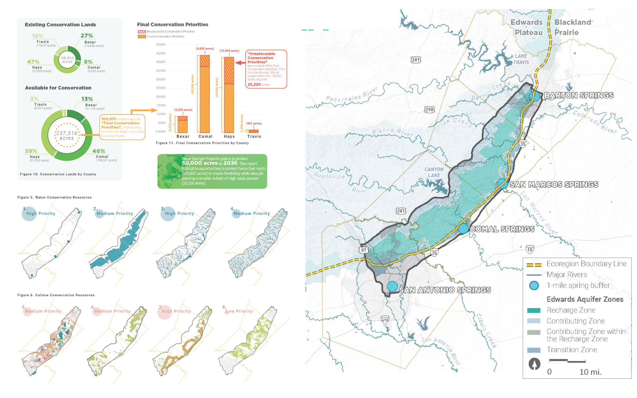
City of Austin Green Infrastructure Assessment • Greater San Marcos Partnership Decision Support Tool • State of the Hill Country Report • Texas Land Trust Council Ecosystem Services • Great Springs Project - Strategic Conservation Prioritization • Guadalupe River Basin Strategic Conservation Plan • Katy Prairie Conservancy Strategic Conservation Prioritization